The 2024 Winter edition of our newsletter is now available in French and English.
This issue has highlights of recent and upcoming events, details on support for Northern Research Assistants and share recent network publications you may have missed. In November last year, the network convened for our fifth Annual General Meeting. Photos, posters, presentations and other details of the event are on our website where you can also download a full report on the meeting.
A study of thermal modeling parameters and their impact on modelled permafrost responses to climate warming
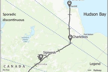
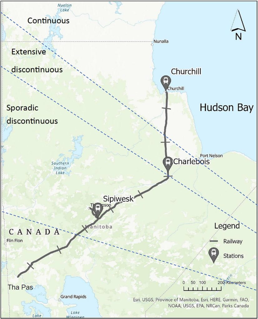
A study by Khatereh Roghangar and Jocelyn Hayley has assessed the effects of thermal modeling parameters on permafrost ground response to climate warming. They analyzed how variations in depth, water content, and soil type affect predictions of future active layer depths and settlement under various climate scenarios using the soil characteristics along Hudson Bay Railway corridor.
The results indicate that, for fine-grained soils, the depth of the model is a more significant parameter than for coarse-grained soils. The water content of all soil types is a critical factor in determining the time at which permafrost thaws and the depth at which the active layer is located, as higher water content leads to larger active layer changes and more settlement in most cases. These findings have important implications for infrastructure and land use management in the Arctic region.
Roghangar, K. and Hayley, J.L. (2024). A study of thermal modeling parameters and their impact on modelled permafrost responses to climate warming. Cold Regions Science and Technology, 221, 104155, DOI: 10.1016/j.coldregions.2024.104155.
The study area showing the Hudson Bay Railway extending from Churchill to The Pas, Manitoba.
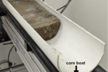
Non-destructive multi-sensor core logging allows for rapid imaging and estimation of frozen bulk density and volumetric ice content in permafrost cores
Exciting research in the Permafrost ArChives Science Laboratory (PACS Lab) at the University of Alberta has demonstrated a novel application of multi-sensor core logging for analyzing permafrost cores.
Measurements of core physical properties are typically destructive and time intensive.
Non-destructive multi-sensor core logging (MSCL) can efficiently analyze permafrost samples and provide high-resolution insights without these problems. The new technique allows rapid imaging, measurement of bulk density and estimation of ice content in permafrost cores. The team were able to visualize cryostructures and estimate frozen bulk density, magnetic susceptibility, and volumetric ice content.
The new technique is described in the paper published in The Cryosphere by Duane Froese’s lab: Pumple, J., Monteath, A., Harvey, J., Roustaei, M., Alvarez, A., Buchanan, C., and Froese, D.: Non-destructive multi-sensor core logging allows for rapid imaging and estimation of frozen bulk density and volumetric ice content in permafrost cores, The Cryosphere, 18, 489–503, https://doi.org/10.5194/tc-18-489-2024, 2024.
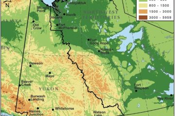
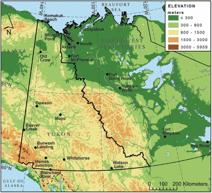
Performance of climate projections for Yukon and adjacent Northwest Territories.
The design of infrastructure on permafrost must account for the impacts of a changing climate on ground stability. While guidelines like CSA PLUS 4011:19 provide a framework, choosing appropriate climate scenarios remains a challenge.
The study by Astrid Schetselaar, Trevor Anderson and Chris Burn reveals that observed warming in the Yukon and Northwest Territories (1991-2020) aligns with more extreme climate projections made in 2003 for the Mackenzie Gas Project.
Key takeaways for developers:
Consider adopting more aggressive climate change scenarios when designing permafrost foundations, as these projections have been more accurate.
Near-surface permafrost in southern parts of the region may become unsustainable. Thorough site investigations for thaw-stable soils are crucial.
Rising winter temperatures imply that the operational efficacy of thermosyphons, used to chill foundations, may be impeded. At sites where preservation of frozen ground is essential for infrastructure integrity, the number of thermosyphons required may need to increase.
Schetselaar, A.B., Andersen, T.S., and Burn, C.R. 2023. Performance of climate projections for Yukon and adjacent Northwest Territories, 1991-2020. Arctic, 76(3). doi: 10.14430/arctic77263
Yukon Territory and western Northwest Territories, including Mackenzie Mountains and adjacent Mackenzie River Valley, with locations of all weather stations.
NSERC PermafrostNet Contributes to Landmark Report on the Future of Arctic and Northern Research in Canada.
NSERC PermafrostNet is proud to have supported and contributed to a groundbreaking new report from the Council of Canadian Academies (CCA) that charts a transformational path forward for Arctic and Northern research in Canada.
For too long, Arctic and Northern research has been dominated by Southern researchers, institutions, and priorities, often ignoring Indigenous Peoples, their rights, cultures, and knowledge systems. The expert panel determined that true transformation requires centering Indigenous leadership, voices, and engagement at all stages of the research process.
PermafrostNet’s Role and Contributions
The CCA assessment was sponsored by a consortium of Arctic and Northern research and science organizations from across Canada, led by ArcticNet, with financial support and input from NSERC PermafrostNet and other leading northern research networks.
PermafrostNet members played critical roles in developing this important report:
Dr. Stephan Gruber, NSERC PermafrostNet Scientific Director and Professor at Carleton University, provided expert input to the panel, drawing on his extensive experience in Arctic research.
Dr. Shawn Marshall, member of NSERC PermafrostNet’s Strategy Committee, glaciologist, and Departmental Science Advisor at Environment and Climate Change Canada, served as a peer reviewer for the report.
Dr. Nicole Wilson, member of NSERC PermafrostNet’s Scientific Committee and Canada Research Chair in Arctic Environmental Change and Governance at the University of Manitoba, also served as a peer reviewer.
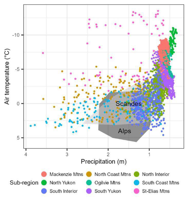
Transferring Cryosphere Knowledge between Mountains Globally: A Case Study of Western Canadian Mountains, the European Alps and the Scandes
Most mountain permafrost research has been focussed on the small area of the European alps. This leads to the question, can you transfer cryosphere knowledge from the Scandes and Alps to Canada?
Comparison of mountain areas with permafrost in western Canada (coloured) and European areas (grey) for mean annual air temperature and total annual precipitation at a resolution of 30 km x 30 km.
Identifying active retrogressive thaw slumps from ArcticDEM
The extent of permafrost thaw in the pan-Arctic remains unknown, but remote sensing, deep learning and crowdsourcing are helping to map permafrost degradation in the landscape.
The recent study by Huanget al study provides data and serves to develop a global inventory and better understand permafrost thaw in the pan-Arctic using very high resolution remote sensing. This approach could lead to a global inventory of retrogressive thaw slumps.
Lingcao Huang, Michael J. Willis, Guiye Li, Trevor C. Lantz, Kevin Schaefer, Elizabeth Wig, Guofeng Cao, Kristy F. Tiampo, Identifying active retrogressive thaw slumps from ArcticDEM, ISPRS Journal of Photogrammetry and Remote Sensing, Volume 205, 2023, Pages 301-316, ISSN 0924-2716.
Coverage of the ArcticDEM in the Arctic with permafrost extent.
Best practices for using electrical resistivity tomography to investigate permafrost
A recent study by Teddi Herring suggests ways to improve how Electrical Resistivity Tomography (ERT) is used for permafrost and highlights recent advances in this approach. ERT is a technique that is incredibly useful for studying permafrost, enabling us to see how deep the permafrost layer is and identify areas with ice content.
There has been a 10-fold increase in publications of studies using ERT to analysis permafrost in the last 20 years, and though challenges remain, and there’s no single “best way” to do it yet, the study makes recommendations for conducting ERT surveys to maximize the utility of existing and future data.
Herring T, Lewkowicz AG, Hauck C, et al. Best practices for using electrical resistivity tomography to investigate permafrost. Permafrost and Periglac Process. 2023; 34(4): 494-512. doi:10.1002/ppp.2207
Global map summarizing locations of field sites where electrical resistivity tomography (ERT) has been used to study permafrost (2000–22) based on the literature search.
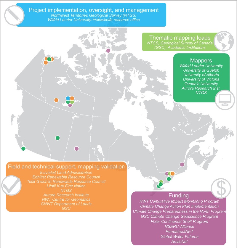
The Northwest Territories Thermokarst Mapping Collective: a northern-driven mapping collaborative toward understanding the effects of permafrost thaw.
A paper by the Thermokarst Mapping Collective (TMC), a research collaborative to systematically inventory indicators of permafrost thaw sensitivity by mapping and aerial assessments across the Northwest Territories (NT), Canada, has documented the first comprehensive inventory of thermokarst and thaw-sensitive terrain indicators for a 2 million km2 region of northwestern Canada.
Kokelj, S.V. et al. The Northwest Territories Thermokarst Mapping Collective: a northern-driven mapping collaborative toward understanding the effects of permafrost thaw. Arctic Science. E First.DOI: 10.1139/as-2023-0009.
Project organization, roles and institutional involvement by location.