Beyond MAGT: learning more from permafrost thermal monitoring data with additional metrics.

Ground temperature is the most common variable in permafrost monitoring and one of three products used to characterize the permafrost Essential Climate Variable by the World Meteorological Organization.

PermafrostNet’s data scientist, Nicholas Brown, has conducted an investigation into the metrics used to assess indicators of permafrost and heat changes in the ground.

Based on this investigation, recommendations are provided for a set of five metrics that offer a more comprehensive picture of permafrost thaw.

Metrics such as the mean annual ground temperature (MAGT) and active layer thickness (ALT) are used to monitor and quantify permafrost change. However, these have limitations including those arising from the effects of latent heat, which reduce their sensitivity.

The team investigated the behaviour of existing and novel metrics derived from temperature observations (TSP metrics) using an ensemble of more than seventy 120-year simulations. They evaluated which TSP metrics provide new insight into permafrost change and evaluated how reliably each one indicates changes in sensible, latent, and total heat contents for different levels of sensor quality. They also quantified the effect of sensor placement on the magnitude of observed MAGT trends.

Brown, N. and Gruber, S. (2025). Beyond MAGT: learning more from permafrost thermal monitoring data with additional metrics, EGUSphere [preprint], DOI: https://doi.org/10.5194/egusphere-2025-2658

Modelling the temporal dynamics of subarctic surface temperature inversions from atmospheric reanalysis for producing point-scale multi-decade meteorological time series in mountains

The vertical profile of air temperatures in subarctic regions is difficult to quantify, especially in areas with mountainous terrain subject to strong and lasting inversion events. 

Relying on observational data is not possible in most places due to sparse weather stations.

Une étude récente de Victor Pozsgay tackles the challenge of developing a model that leverages atmospheric reanalysis data and calibrates it using data from five weather stations in the Yukon, Canada.

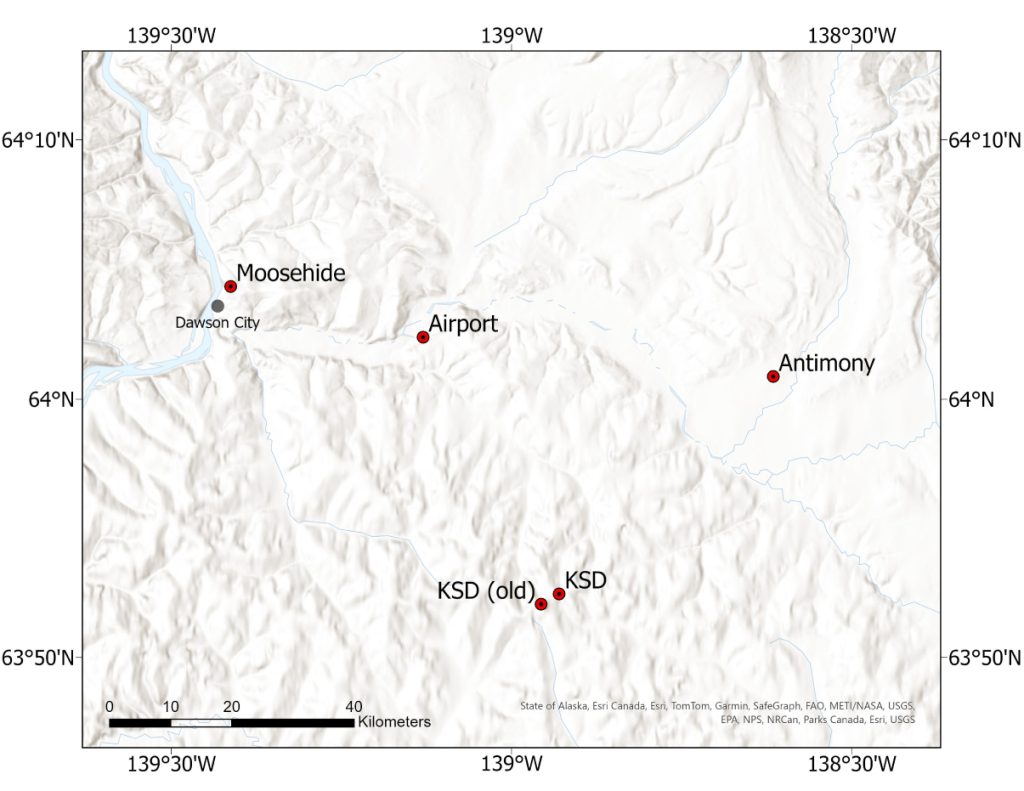
Map of the study area showing the five sites around Dawson City, Yukon Territory, Canada. The basemap is composed of the Esri World Terrain Base and Esri World Hillshade layers, and is projected in the WGS 1984 Web Mercator projection.

Accurately tracking air temperatures in subarctic mountainous regions is a challenging task, especially due to the prevalence of strong and frequent temperature inversions. These inversions play a critical role in shaping permafrost distribution and regional climate dynamics, yet traditional observations are sparse because of the lack of weather stations in rugged terrain. Victor’s study tackles this challenge by developing a model that leverages atmospheric reanalysis data and calibrates it using actual data from the Yukon. The calibrated model successfully reflects the trends in inversion frequency, strength, and depth that have been evolving since 1948, departing from typical warming patterns seen elsewhere. This approach makes it possible to produce reliable, point-scale meteorological time series for even the most inaccessible locations—an essential advance for studies of permafrost and the broader climate system. The model’s reliance on global reanalysis data and minimal location-specific calibration means it is poised to be both future-proof and widely applicable for regional climate applications, offering a much-needed solution for addressing data gaps in complex, mountainous terrains.

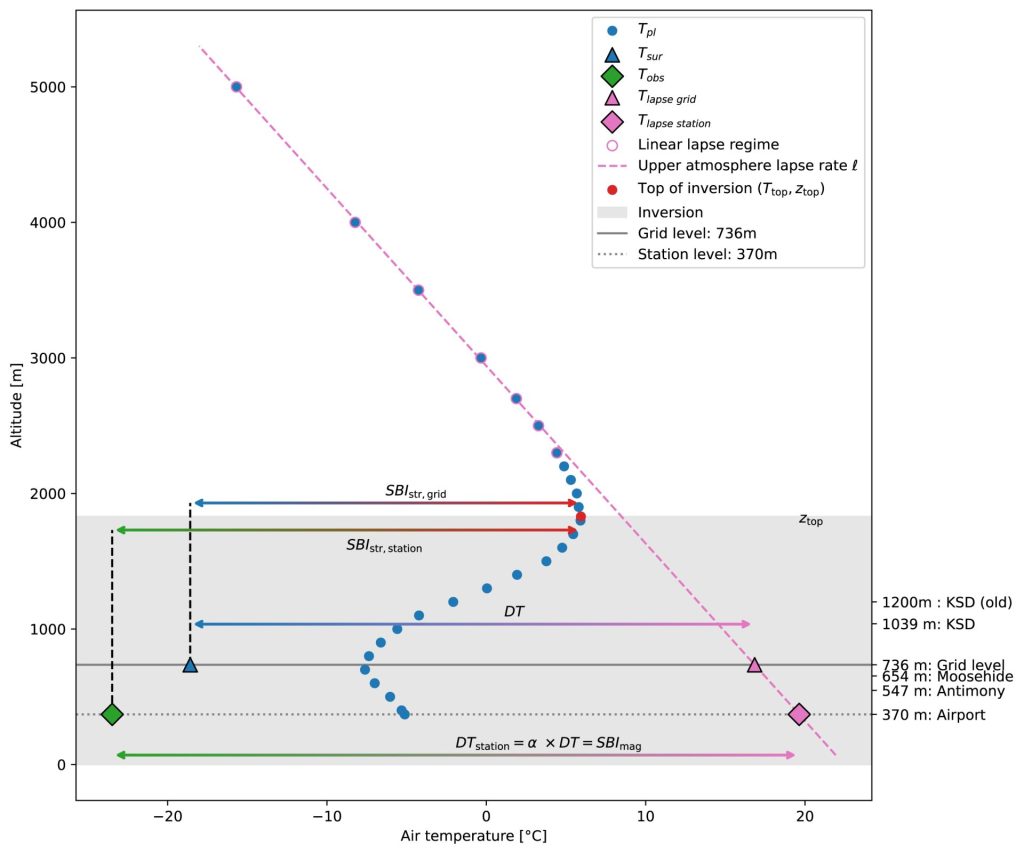
Mean daily pressure-level temperatures for several altitudes at and above the Dawson Airport (ERA5 data on 1 February 2007). The dependence with altitude is linear above 2300 m, where the linear lapse rate can be fitted. Below this, a ‘‘lapse’’ temperature is extrapolated at the grid and station levels. In the grey band, the altitudinal temperature behaviour is inverted, increasing with elevation. The elevation of the five stations used is reported on the right-hand side. The reanalysis data appear in blue, with points representing the pressure level air temperature Tpl and a triangle at the grid level for the surface temperature Tsur. Finally, the observed temperature Tobs is a green diamond at the station’s elevation.

Victor Pozsgay and Stephan Gruber. 2025. Modelling the temporal dynamics of subarctic surface temperature inversions from atmospheric reanalysis for producing point-scale multi-decade meteorological time series in mountains. Arctic Science11: 1-16. https://doi.org/10.1139/as-2025-0027

Land Claims Agreement Coalition Conference 2020

“Until this conference I wasn’t aware of the extent of Modern Treaties Territories, but I know that permafrost is distributed across much of northern Canada. The conference made me realize that these Territories almost completely overlap the permafrost zones in Canada. Several northern communities are severely impacted by climate change and thawing permafrost, but it really hits home that most of the future permafrost changes will occur within Modern Treaties Territories.”

Peter Morse, CPA Secretary and NSERC PermafrostNet collaborator

On 11 and 12 February 2020, the Land Claims Agreement Coalition held their 8th National Conference, Making Modern Treaties Work: Building Today for a Better Tomorrow in Gatineau, QC.

NSERC PermafrostNet and the Canadian Permafrost Association came together to share a booth at the conference. The event provided a great opportunity to introduce our two organizations, explain what we do and hear about the climate-change related challenges faced by Indigenous communities.

The conference featured high-profile Canadian and international speakers, First Nation and Inuit leaders and youth, leading to meaningful discussions of timely legal, cultural and governance issues. The sessions focused on academic and technical training and improving intergovernmental relationships. Esteemed and inspiring speakers, included: Dana Tizya-Tramm, Chief, Vuntut Gwitchin First Nation, Daniel Watson, Deputy Minister of CIRNAC, P.J. Akeeagok, President of the Qikiqtani Inuit Association and Gregor Gilbert, Director, Department of Environment, Wildlife, and Research at Makivik Corporation.

Photos: Tristan MacLean

Theme 1 workshop

Theme 1 and Database Development Workshop

“It was very convenient to be able to connect to the workshop remotely so that I could get an update on other people’s work and so I could give an update on my research as well. I like how the network ensures everybody can attend important meetings while also helping to lower our carbon footprint.”

Ariane Castagner

In February 2020 Theme 1 organized a two-day database development meeting in Ottawa that brought together investigators, graduate students, government collaborators and the network data scientist. This was the network’s first hybrid event, with some participants joining virtually using ZOOM, a video conferencing platform. 

The event began on Thursday 6 February with a discussion about the existing ground ice maps for Canada.  Brendan O’Neill and Steve Wolfe presented the most recent GSC ground ice map (O’Neill et al. 2020), and the group discussed the possible areas for improvement and future. In the afternoon, students Joe Young, Alejandro Alvarez and Ariane Castagner presented on their research.

On Friday, Steve Kokelj introduced the NWT Thermokarst Mapping Initiative and discussed possibilities for evaluating the Ground Ice Distribution and thermokarst potential. Next, the group reviewed regional datasets that could be used to test or improve ground ice mapping; Peter Morse, Ariane Castagner, Ashley Rudy, Panya Lipovsky, Pascale Roy Léveillée, Daniel Fortier and Toni Lewkowicz each presented datasets from their study sites or area of expertise. These datasets ranged in geography from the Yukon to the Hudson Bay Lowlands to the polar deserts of the high arctic.

This was followed by a discussion of some of the key questions for the PermafrostNet Ground Ice Potential map: whether test sites should be used for evaluation (and how such and evaluation might be done!) and how the maps might move past rule-based strategies to include remotely sensed or hybrid models.

Finally, Nick Brown presented on the existing database structures that could be used for compiling diverse permafrost data for the network, and initiated discussion about how to improve the database to meet the needs of the network. This also included a discussion of how ground ice mapping efforts could benefit from the PermafrostNet partnership with CCADI. 

Photos: Nick Brown and Emma Stockton