Many changes in cold regions are amplified by nonlinear processes involving ice and have important consequences locally and globally.
The climate-driven changes in cold regions have an outsized importance for local resilient communities and for global climate through teleconnections. Bin Cao and Stephan Gruber show that reanalyses are less accurate in cold regions compared to other more populated regions, coincident with the low density of observations. Our findings likely point to similar gaps in our knowledge and capabilities of climate research and services in cold regions.

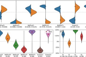
The 1991–2020 average ensemble spread of (a) mean annual air temperature (MAAT) and (b) relative maximum snow water equivalent (maxSWE) among different reanalyses.
The ensemble spread in the mean annual maximum snow water equivalent is found to be greater than the ensemble mean. The reduced quality of reanalyses in cold regions, coinciding with sparse in situ observations and low population, points to challenges in how we represent cold-region phenomena in simulation systems and limits our ability to support climate research and services.

Cao, B. and Gruber, S.: Brief communication: Reanalyses underperform in cold regions, raising concerns for climate services and research, The Cryosphere, 19, 4525–4532, https://doi.org/10.5194/tc-19-4525-2025, 2025.